Local Government
West Arthur
Region
Wheatbelt
Darkan
Darkan Railway Reserve
West Arthur
Wheatbelt
| Type | Status | Date | Documents |
|---|---|---|---|
| (no listings) |
| Type | Status | Date | Documents |
|---|---|---|---|
| (no listings) |
| Type | Status | Date | Grading/Management | |
|---|---|---|---|---|
| Category | ||||
| Municipal Inventory | Adopted | 27 Mar 1997 | Category 4 | |
02703 Darkan Railway Station Precinct
Tree
| Epoch | General | Specific |
|---|---|---|
| Original Use | PARK\RESERVE | Park\Reserve |
This information is provided voluntarily as a public service. The information provided is made available in good faith and is derived from sources believed to be reliable and accurate. However, the information is provided solely on the basis that readers will be responsible for making their own assessment of the matters discussed herein and are advised to verify all relevant representations, statements and information.
Constructed from 2000, Constructed from 1906
The Sarah Ann Gibbs Tree is an important representation of the pioneering women of the district.
A pine tree was planted on the Railway Reserve on the northern side of the Railway Station in 1906 by Mrs Sarah Ann Gibbs the wife of pioneer settler William Gibbs. A plaque was erected on the tree in 1947 and it read: “This tree was planted in 1906 by Mrs. Sarah Ann Gibbs, wife of pioneer settler William Gibbs. Born near Brunswick in 1854. Mrs. Gibbs lived at Boolading Farm for over 70 years and died on 30th July 1946 at the age of 92 years. Erected in memory of a pioneer country woman by the Darkan Branch, CWA.” The Pine tree was deemed unsafe by the Shire Council and was felled in 1990 and a 1m stump left in the ground. The stump was later removed. Members of the community considered the tree so important that it was replaced with a young pine tree that was transplanted from the Boolading Siding in 2001. A second plaque was attached to the stump of the felled tree and it read: “This plaque marks the site of the Sarah Ann Gibbs tree removed 1990. Another pioneer tree and several native trees have been planted nearby to replace this tree.” These plaques are both currently stored in the Shire strong room.
The following excerpt was taken from the Collie Mail circa 1947: “On a pine tree at the entrance of the Darkan Railway Station a memorial tablet to the late Mrs. Sarah Ann Gibbs was recently unveiled. Mrs. Gibbs who died l8 months ago lived in the Darkan district for over 70 years. The unveiling ceremony was organised by the Darkan CWA and the branch president Mrs. J.H.Spencer presided. Branch members, together with many relatives and friends of the late Mrs. Gibbs were present. The memorial tablet was unveiled by the West Arthur Road Board chairman Mr. Don Johnston.”
Modifications: A new tree has been planted to replace the original tree which was deemed unsafe. Extent of original fabric: None
| Ref ID No | Ref Name | Ref Source | Ref Date |
|---|---|---|---|
| Council Minutes. p 330 | Shire of West Arthur | 21 June 1990 | |
| Council Minutes | Shire of West Arthur | 2001 |
| Owner | Category |
|---|---|
| Shire of West Arthur | Local Gov't |
This information is provided voluntarily as a public service. The information provided is made available in good faith and is derived from sources believed to be reliable and accurate. However, the information is provided solely on the basis that readers will be responsible for making their own assessment of the matters discussed herein and are advised to verify all relevant representations, statements and information.
Burrowes St Darkan
West Arthur
Wheatbelt
Constructed from 1908
| Type | Status | Date | Documents |
|---|---|---|---|
| (no listings) |
| Type | Status | Date | Documents |
|---|---|---|---|
| (no listings) |
| Type | Status | Date | Grading/Management | |
|---|---|---|---|---|
| Category | ||||
| Municipal Inventory | Adopted | 27 Mar 1997 | Category 2 | |
Individual Building or Group
| Epoch | General | Specific |
|---|---|---|
| Original Use | EDUCATIONAL | Combined School |
| Present Use | EDUCATIONAL | Combined School |
| Type | General | Specific |
|---|---|---|
| Other | TIMBER | Other Timber |
| Roof | METAL | Corrugated Iron |
| General | Specific |
|---|---|
| SOCIAL & CIVIC ACTIVITIES | Education & science |
This information is provided voluntarily as a public service. The information provided is made available in good faith and is derived from sources believed to be reliable and accurate. However, the information is provided solely on the basis that readers will be responsible for making their own assessment of the matters discussed herein and are advised to verify all relevant representations, statements and information.
Constructed from 1908
The building is closely associated with the provision of educational facilities. It is the first school in the West Arthur district. The building is a good example of the building style of the period. It is an important part of the town’s original building stock and makes a positive contribution to the streetscape.
The school is located on the western outskirts of Darkan fronting the Duranillin road. The location was possibly chosen to also serve children to the farming districts to the west, south and north of the town. The first building was later incorporated into two additions- the first joined to it on the north side and the major extensions to the east. The old building was then used as the office and administration centre. It is a timber framed, hip roof building with a wooden dado and fibre cladding. The dado and cladding probably occurred with the additions to give a uniform appearance.
The increasing population accompanying the railway to Darkan saw the approval of a school building for the township. In early 1908 it was announced that H. Marsh of Narrogin was the successful tenderer at the cost of 475 pounds (21). The Boolading residents considered the school should have been built at their centre and renewed their representation with enthusiasm. Finally, after two years of agitation, the Education Department granted 20 pounds for the materials on the condition that the Boolading settlers erect the building. Until 1929, the school was run by just one teacher. In that year a ‘probationer’ was appointed as an assistant. The growth of the town’s population and the advent of the school buses after WW II saw a rapid expansion in student and teacher numbers. In 1962 the school was given ‘Junior High’ status and in 1974 reclassified as ‘District High School’ (1).
Modifications: Some (attachment to later additional buildings) Extent of original fabric: Most
Good
| Ref ID No | Ref Name | Ref Source | Ref Date |
|---|---|---|---|
| J Bird; "West of Arthur". pp 204, 286, 380 |
| Owner | Category |
|---|---|
| Education Department | State Gov't |
This information is provided voluntarily as a public service. The information provided is made available in good faith and is derived from sources believed to be reliable and accurate. However, the information is provided solely on the basis that readers will be responsible for making their own assessment of the matters discussed herein and are advised to verify all relevant representations, statements and information.
29 Burrowes St Darkan
Lot 23
Agricultural Protection Board
West Arthur Roads Board
West Arthur
Wheatbelt
Constructed from 1929
| Type | Status | Date | Documents |
|---|---|---|---|
| (no listings) |
| Type | Status | Date | Documents |
|---|---|---|---|
| (no listings) |
| Type | Status | Date | Grading/Management | |
|---|---|---|---|---|
| Category | ||||
| Classified by the National Trust | Classified | 08 May 2000 | ||
| Municipal Inventory | Adopted | 27 Mar 1997 | Category 2 | |
Individual Building or Group
| Epoch | General | Specific |
|---|---|---|
| Present Use | GOVERNMENTAL | Office or Administration Bldg |
| Original Use | Transport\Communications | Road: Office or Administration Bldg |
| Style |
|---|
| Federation Free Style |
| Type | General | Specific |
|---|---|---|
| Roof | METAL | Corrugated Iron |
| Wall | BRICK | Common Brick |
| General | Specific |
|---|---|
| TRANSPORT & COMMUNICATIONS | Road transport |
This information is provided voluntarily as a public service. The information provided is made available in good faith and is derived from sources believed to be reliable and accurate. However, the information is provided solely on the basis that readers will be responsible for making their own assessment of the matters discussed herein and are advised to verify all relevant representations, statements and information.
Constructed from 1929
The building is closely associated with the provision of local government services. It was built initially for the Road’s Board and was later occupied by the users. The building is a good example of the building style from the period, it is an important part of the town’s building stock and makes a positive contribution to the streetscape.
Situated in Burrowes Street it replaced the old weatherboard offices on the same site. The building has a distinctive parapet wall with a pediment over the front entrance. The walls are buttressed and the building features a central fireplace which is part of the dividing wall between the front office section and the rear meeting /storage room. Since the new Shire Complex was built in the 1960’s, the building has been used as archival storage and local newspaper (Bleat) in the rear, while the front office has been used by the Police the local APB officer, and for a short period the Darkan Toy Library. With access now available through the Health and Resources Centre the building is used for meetings, as a board room or for presentations.
The mid-20’s brought to a head some of the complex problems facing the West Arthur Roads Board. A number of widely scattered localities were developing their own communities, and some resentment was felt towards the centralised operations of the board in Darkan. In March 1925, a special meeting of ratepayers overwhelmingly carried out a motion of no confidence in the Board. Evidently discontent was due to the inequitable expenditures in the various wards, and the representation of the wards on the Roads Board (1). The direction by the Minister for Local Government that an increase of board members from seven to nine guaranteed at least two new faces on the Roads Board and when two of the old Board (2) declined to stand for re-election, a new-look Board was guaranteed. The following April (1927), a referendum was held to determine “the desirability or otherwise of the removing the Roads Board office to Duranillin.” The result was a resounding “NO” vote of 335, to a “YES” tally of only 147 votes (3). The majority of more than 2:1 in favour of the office remaining in Darkan had settled this question, which had been simmering for a number of years. At the monthly meeting of the Board in February 1928, Board Members Johnson and Curnow put forward a motion that the new office of either brick, stone or cement bricks be built at Darkan, at an estimated cost of about seven hundred and fifty pound. However, Robert Ness successfully moved an amendment that the matter of building a new office of brick or stone be referred to the ratepayers at the Annual General Meeting to be held at Darkan on 15 March. This matter was apparently deferred until a referendum was finally held in December of that year. A narrow majority of 26 gave the go ahead for the new offices (4). Tenders were called early the following year for the brick office and board room, and work commenced in mid-1929.
Modifications: Few (Doorways) Extent of original fabric: Floorboards have been replaced and some restoration had been undertaken. Access available through the Health and Resources Centre since 2000. The original counter in the front room has been removed.
Excellent
| Ref ID No | Ref Name | Ref Source | Ref Date |
|---|---|---|---|
| Ibid | 10/4/25 | ||
| J Bird; "West of Arthur". pp 309-311 | |||
| Ibid | 6/4/26 | ||
| "Wagin Argus". | 23/3/25 | ||
| Ibid | 18/12/28 |
| Owner | Category |
|---|---|
| Shire of West Arthur | Local Gov't |
This information is provided voluntarily as a public service. The information provided is made available in good faith and is derived from sources believed to be reliable and accurate. However, the information is provided solely on the basis that readers will be responsible for making their own assessment of the matters discussed herein and are advised to verify all relevant representations, statements and information.
35 Burrowes St Darkan
Lot 34
West Arthur
Wheatbelt
Constructed from 1933
| Type | Status | Date | Documents |
|---|---|---|---|
| (no listings) |
| Type | Status | Date | Documents |
|---|---|---|---|
| (no listings) |
| Type | Status | Date | Grading/Management | |
|---|---|---|---|---|
| Category | ||||
| Municipal Inventory | Adopted | 27 Mar 1997 | Category 3 | |
Individual Building or Group
| Epoch | General | Specific |
|---|---|---|
| Original Use | Transport\Communications | Road: Other |
| Present Use | Transport\Communications | Road: Other |
| Type | General | Specific |
|---|---|---|
| Wall | METAL | Corrugated Iron |
| Roof | METAL | Corrugated Iron |
| General | Specific |
|---|---|
| TRANSPORT & COMMUNICATIONS | Road transport |
This information is provided voluntarily as a public service. The information provided is made available in good faith and is derived from sources believed to be reliable and accurate. However, the information is provided solely on the basis that readers will be responsible for making their own assessment of the matters discussed herein and are advised to verify all relevant representations, statements and information.
Constructed from 1933
Notable as the site of the first garage/mechanical repairs in Darkan and its association with transition from horse drawn vehicles to the motor age. It is also significant that the original building used local timber and was constructed by pioneers.
Situated on the south side of Burrowes St. almost opposite the Stationmaster’s House. The only remaining section of the original structure is a small room fronting the street. The rest of the building was purchased and removed by Don Telfer. Originally constructed in the period 1933-35 by Tom and Fred Curnow using timber cut on the family’s ‘The Angle’ property at Boolading. Later owners have made extensive alterations and modifications since that time. After the Second War the business was sold to Dorsett’s Motor Agency- Fred Curnow managed it for a time, then CL Elias and Pat Chapman. The next owner was George Elias then Alf Galloway and the present owners- the Putland family since 1963. (1) At the rear of the garage is the old lighting plant shed- timber framed weather clad with iron gable roof. There is one opening, a double door made of wooden planks.
The original builders and proprietors Fred and Tom Curnow were two of 12 children of Jim and Sophia (nee Gibbs). Each of the seven sons displayed a strong degree of technical ability- a trait inherited from their father who made a valuable contribution to the district for many years as a wheelwright/blacksmith. Jim Curnow had learned this trade as a young man on the Goldfields after leaving the family farm in Victoria and teamed up with his brother-in-law Jim Wunnenberg to set up a blacksmith business in Kookyine. In 1937 the Curnow brothers introduced the first 32 volt lighting plant to the district. Fred served in the Air Force during the Second World War and it was left to the younger boys to carry out most of the district’s mechanical and electrical repairs. Tom went to Quindanning and served a term as President of the Boddington Shire Council. He later retired to Bunbury and served on the bench of the Children’s Court. In later years Fred continued with his inventions and had success with a grain dryer and seed cleaner inventions. Other owners have included Norm Dorsett, Geoff Elias and Alf Galloway. The current owners purchased the garage from Alf in 1963.
Modifications: Many Extent of original fabric: Part (small room fronting Burrowes St)
Good – some cladding needs replacing
| Ref ID No | Ref Name | Ref Source | Ref Date |
|---|---|---|---|
| J Bird; "West of Arthur". pp155-156, 378 |
| Owner | Category |
|---|---|
| JW and LD Putland | Other Private |
This information is provided voluntarily as a public service. The information provided is made available in good faith and is derived from sources believed to be reliable and accurate. However, the information is provided solely on the basis that readers will be responsible for making their own assessment of the matters discussed herein and are advised to verify all relevant representations, statements and information.
Coalfields Hwy Darkan
Location 38
West Arthur
Wheatbelt
Constructed from 1900
| Type | Status | Date | Documents |
|---|---|---|---|
| (no listings) |
| Type | Status | Date | Documents |
|---|---|---|---|
| (no listings) |
| Type | Status | Date | Grading/Management | |
|---|---|---|---|---|
| Category | ||||
| Municipal Inventory | Adopted | 27 Mar 1997 | Category 3 | |
Individual Building or Group
| Epoch | General | Specific |
|---|---|---|
| Present Use | FARMING\PASTORAL | Homestead |
| Original Use | FARMING\PASTORAL | Homestead |
| Type | General | Specific |
|---|---|---|
| Wall | STONE | Other Stone |
| Roof | METAL | Corrugated Iron |
| General | Specific |
|---|---|
| PEOPLE | Early settlers |
This information is provided voluntarily as a public service. The information provided is made available in good faith and is derived from sources believed to be reliable and accurate. However, the information is provided solely on the basis that readers will be responsible for making their own assessment of the matters discussed herein and are advised to verify all relevant representations, statements and information.
Constructed from 1900
The building is notable as it stands on the first location taken up in the Darkan area and is still owned by descendants of the original pioneers - William and Sarah Gibbs. It also is a good example of construction styles of this period and is an important part of the district’s building stock.
Situated near the Darkan Gully which took its name, as did the farm and later the township, from the Darkan Rock a flat granite rock. It is the only steep granite rise along the gully and probably accounts for the location of a large stone well (about 3-4 m in diameter) which was the source of water for the family (it is situated near the south west corner of the home). The house has no eaves and is notable for the elevation of the front which has a landing, initially wooden steps. The timber floor was supported by stone pillars. Internal cladding is crimped iron. Corner fireplaces served the three large rooms on the west side of the central passageway. A weatherboard extension to the rear of the house served as the kitchen, it is also crimped iron clad on the inside. Surrounding the homestead (which is about 200m west of the Williams/Darkan Road and 100m east of the Coalfields Highway) is an extensive orchard and on the east there are remnants of a tennis court.
The William Gibbs family originally set up camp approximately two and a half miles west of Darkan. The well at the camp was unreliable, and a better one was sunk further down the creek, and camp was shifted to the new place. They decided to settle permanently and on 25 June 1867, applied for a tillage lease of 100 acres, one mile from Darkan Rock. Other land was selected in later years. The Gibbs’ also made a living from kangaroo skins, which they took to Perth and traded for provisions etc. (1) The death of the Darkan pioneer, William John Gibbs in June 1895, and his wife, Harriet, just seven months later, was the end of a very significant chapter in the district’s history. Their youngest son, Henry, who was then 37 years of age, took over the running of the ‘Darkan’ homestead farm and in later years extended the boundaries west of the Quindanning Road to take in 1600 acres of land. In 1896, Henry Gibbs became a member of the re-constituted Arthur Road Board and served on that body for 29 years. About this time, he married Eleanor Harris and the couple were to produce 10 children with the eldest, Herbert, being killed in action in France in June 1916, when only 18 years of age. In 1912 a travelling correspondent reported - “Darkan House”, residence of Henry Gibbs, one of the oldest in the district, 40 years standing. Of late years, nice stone house erected ... one hundred acres late sown. Horses, cattle help keep pot boiling. With crops and high price of wool, most Darkan folk should be in a position to visit the Royal next year in their motor cars (22). Henry and Eleanor’s third son George married Linda Lynch in 1935. He took over ‘Darkan’ farm (now ‘Sunnyhurst’) from his father. George served in World War II and had two sons, Don and Stewart, the latter running the property until his death in 1987.
Modifications: Few Extent of original fabric: Most
Poor
| Ref ID No | Ref Name | Ref Source | Ref Date |
|---|---|---|---|
| J Bird; "West of Arthur". pp 76, 126, 258 |
| Owner | Category |
|---|---|
| H Gibbs | Other Private |
This information is provided voluntarily as a public service. The information provided is made available in good faith and is derived from sources believed to be reliable and accurate. However, the information is provided solely on the basis that readers will be responsible for making their own assessment of the matters discussed herein and are advised to verify all relevant representations, statements and information.
4 Coalfields Hwy Darkan
Lot 3
West Arthur
Wheatbelt
Constructed from 1906
| Type | Status | Date | Documents |
|---|---|---|---|
| (no listings) |
| Type | Status | Date | Documents |
|---|---|---|---|
| (no listings) |
| Type | Status | Date | Grading/Management | |
|---|---|---|---|---|
| Category | ||||
| Municipal Inventory | Adopted | 27 Mar 1997 | Category 2 | |
| Statewide Hotel Survey | Completed | 01 Nov 1997 | ||
Individual Building or Group
| Epoch | General | Specific |
|---|---|---|
| Original Use | COMMERCIAL | Hotel, Tavern or Inn |
| Present Use | COMMERCIAL | Hotel, Tavern or Inn |
| Type | General | Specific |
|---|---|---|
| Wall | STONE | Other Stone |
| Roof | METAL | Corrugated Iron |
| Wall | BRICK | Common Brick |
| General | Specific |
|---|---|
| OCCUPATIONS | Hospitality industry & tourism |
This information is provided voluntarily as a public service. The information provided is made available in good faith and is derived from sources believed to be reliable and accurate. However, the information is provided solely on the basis that readers will be responsible for making their own assessment of the matters discussed herein and are advised to verify all relevant representations, statements and information.
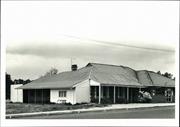
Constructed from 1906
The place is significant on the following grounds: The hotel has played an important role in the community as a meeting place and venue for social events. A fine example of a country hotel, it makes a significant contribution to the streetscape and the architectural heritage of Darkan.
Located on one of the lots surveyed off the Burrowes’ farm. It was built of local stone and opened on 5 November 1906. It was described at that time; “The most prominent building is the Darkan Hotel, belonging to Mrs. Francis, who has spared no effort in making it most comfortable in every way. It is built of stone, and comprises 14 large rooms, seven of which are bedrooms, whilst the dining room measures 25 feet by 16. There are two bathrooms and three parlors for the convenience of travellers. Everything is up-to-date. There are two pianos, and the furniture is first-class throughout. Verandahs almost surround the building, and there are other conveniences such as a six-stall stable, wash house, large tank etc.” (1) Alterations have taken place over time, but the original building is still the hub of the hotel. A major brick extension to the SE corner of the old hotel in the 1960’s resulted in the bar being enlarged and now faces the Coalfields Highway. Prior to this there were two smaller bars facing east.
Over the 101 years of operation the hotel has had many owners and licensees.
Modifications: Some brick Extent of original fabric: Most
Good
| Ref ID No | Ref Name | Ref Source | Ref Date |
|---|---|---|---|
| J Bird; "West of Arthur". pp 200-205, 210 | |||
| "Southern Argus". | 3/11/1906 | ||
| "Southern Argus". | 4/5/1907 |
| Owner | Category |
|---|---|
| Kim and Inga Arundal | Other Private |
This information is provided voluntarily as a public service. The information provided is made available in good faith and is derived from sources believed to be reliable and accurate. However, the information is provided solely on the basis that readers will be responsible for making their own assessment of the matters discussed herein and are advised to verify all relevant representations, statements and information.
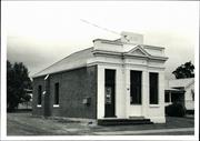
5 Coalfields Hwy Darkan
Lot 7
West Arthur
Wheatbelt
Constructed from 1925
| Type | Status | Date | Documents |
|---|---|---|---|
| (no listings) |
| Type | Status | Date | Documents |
|---|---|---|---|
| (no listings) |
| Type | Status | Date | Grading/Management | |
|---|---|---|---|---|
| Category | ||||
| Municipal Inventory | Adopted | 27 Mar 1997 | Category 3 | |
Individual Building or Group
| Epoch | General | Specific |
|---|---|---|
| Original Use | COMMERCIAL | Bank |
| Present Use | COMMERCIAL | Shop\Retail Store {single} |
| Type | General | Specific |
|---|---|---|
| Wall | TIMBER | Weatherboard |
| Roof | METAL | Corrugated Iron |
| General | Specific |
|---|---|
| OCCUPATIONS | Commercial & service industries |
This information is provided voluntarily as a public service. The information provided is made available in good faith and is derived from sources believed to be reliable and accurate. However, the information is provided solely on the basis that readers will be responsible for making their own assessment of the matters discussed herein and are advised to verify all relevant representations, statements and information.
Constructed from 1925
The building is closely associated with the provision of banking facilities for the area and played a significant role in the development of the town.
Located on Coalfields Highway on one of the lots surveyed from Burrowes farm for the unofficial townsite. The original Bank was a one roomed, gable roof building with a front verandah. A picket fence ran along the edge of the footpath. A new bank in 1951 used the same roofline but was a far larger building.
Soon after the railway reached Darkan in 1906, local residents began petitioning for a branch of the National Bank to be established. (1) The National Bank first opened in Darkan on 19 August 1909, as an agency of the Williams branch and was serviced weekly. At the height of the Second World War it was closed for six months before reopening on 7 January 1943, as a receiving office. This was a slightly different type of operation to an agency, but was still connected with the Williams branch. The building of the new National Bank premises at Darkan marked the conversion, on 20 September 1951, to a full time branch under the management of G.S.S. Williams. The branch, from this time operated its own agency at Duranillin until 10 October 1963, when this facility ceased. Since 1951, the branch based at this building had eighteen managers who have averaged two years at Darkan. The managers since G.S.S. Williams have been G.S. Jackson, B.W. Bloomfield, P.G. Cambell, D. Lane, R.M. Firth, R.F. Backhouse, A.F. Watson, B.L. Brownfield, R.W. Campbell, L.E. Hately, S.I. Jarvis, L.C. Manners, A.W. Jefferys, N.F. Cashell, G.L.Swain, D.J. Allen, G.E. Marshall and S. Guile. (2) A new bank building was constructed in 1990 across the railway in Burrowes Street. A house for the branch manager was built opposite the railway station in Burrowes Street during the 1960’s. The old building was used as a hairdressers premises up until 2002, when it was purchased by Des and Ellen Gooding. It is currently used as an Opportunity Shop (Oppy Shop) to raise funds for Charity.
Modifications: Extensive enlargements Extent of original fabric: Most (original ceiling has been replaced)
Good
| Ref ID No | Ref Name | Ref Source | Ref Date |
|---|---|---|---|
| Shire Archival Records | Shire of West Arthur | ||
| J Bird; "West of Arthur". pp 202, 204 | Southern Argus | 4/5/1907 | |
| G.E. Marshall (National Bank); "Correspondence T.O. Perry (Darkan)". |
| Owner | Category |
|---|---|
| D & E Gooding | Other Private |
This information is provided voluntarily as a public service. The information provided is made available in good faith and is derived from sources believed to be reliable and accurate. However, the information is provided solely on the basis that readers will be responsible for making their own assessment of the matters discussed herein and are advised to verify all relevant representations, statements and information.
Coalfields Rd Darkan
West Arthur
Wheatbelt
| Type | Status | Date | Documents |
|---|---|---|---|
| (no listings) |
| Type | Status | Date | Documents |
|---|---|---|---|
| (no listings) |
| Type | Status | Date | Grading/Management | |
|---|---|---|---|---|
| Category | ||||
| Municipal Inventory | Adopted | 27 Mar 1997 | Category 2 | |
02703 Darkan Railway Station Precinct
Individual Building or Group
| Epoch | General | Specific |
|---|---|---|
| Present Use | COMMERCIAL | Shop\Retail Store {single} |
| Original Use | Transport\Communications | Rail: Railway Station |
| Type | General | Specific |
|---|---|---|
| Wall | STONE | Other Stone |
| Wall | BRICK | Common Brick |
| Other | TIMBER | Other Timber |
| Roof | METAL | Corrugated Iron |
| General | Specific |
|---|---|
| TRANSPORT & COMMUNICATIONS | Rail & light rail transport |
This information is provided voluntarily as a public service. The information provided is made available in good faith and is derived from sources believed to be reliable and accurate. However, the information is provided solely on the basis that readers will be responsible for making their own assessment of the matters discussed herein and are advised to verify all relevant representations, statements and information.
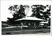
Constructed from 1912
The place is significant on the following grounds: The Station played an important role in the community providing a link to Perth, the Great Southern and the South West and for telegraphic communications in the early days. The building is an important part of the railway network that linked Collie and Narrogin. The building is a good example of the building style from the period. It is an important part of the town’s original building stock and makes a positive contribution to the streetscape. The first survey made for the Collie - Narrogin Railway followed its present course, from Narrogin to about Culbin siding, then turned south-west and straight towards Collie until joining the present railway near Cowcher siding, about 10 miles north-east of Collie. This survey passed approximately 12 miles north of the present site of Darkan. This was later changed to the present route. Mounting political pressure from both ends of the line resulted in a decision in April 1905, to extend the Narrogin-Williams spur to Darkan. The Narrogin-Darkan section was opened on 6 September 1906, and it is said that the steam engines from Narrogin initially burned wood to generate steam as coal was not immediately available in Narrogin. The Collie-Darkan section was opened on Monday 7 October 1908.(3)
The siting of the siding at this point dictated the position of the commercial buildings such as the refreshment rooms. The building has sash windows, overhanging eaves and wire covered vents to eaves. The east and north walls have modifications where a door/windows have been bricked in - possibly when being built as a variation to the standard design.
The new railway brought with it the necessity to formally declare and name townsites and sidings along its route. The town of Darkan was officially gazetted on 7 December 1906, and took the name from the Darkan Rock, which was situated in the Darkan Gully (Surveyor of W.A. Saw, April 1889). Similarly the name “Darkan”, given to the nearby home of William Gibbs, was taken from Darkan Rock. (1) The townsite of Darkan was surveyed south of the railway line, but the first building blocks were surveyed out of Bill Burrowes’ farm on the north of the railway line. It was on these blocks outside of the official townsite that the first business houses in Darkan were built. The contract to build Darkan was advertised in the “Government Gazette” on the 19 May 1911. The successful tender from Mr. H. Parker, was accepted on the 17 August 1911 (His bid for 4 identical buildings was £1776-6-6, or about £444 each). The completion date is recorded by the WAGR as 14 December 1912, but this included the new Goods Shed and Ladies Waiting Room as well. It is likely the station building was completed early in 1912. The Stationmaster’s house was commenced on 17 February 1912 and completed later in the year. Darkan is amongst a group of seven identical stations built during 1911-17. They are Darkan, Bowelling, Popanyinning, Wickepin, Kondinin, Dumbleyung and Northamption. Only Kondinin has been demolished. (2) Following the closure of the Narrogin-Bowelling line the building lay idle. The Building was used as an ‘Op Shop’ for a period. It is now used for “one-off” events held on the Railway Reserve.
Modifications: Few Extent of original fabric: All
Good
| Ref ID No | Ref Name | Ref Source | Ref Date |
|---|---|---|---|
| Australian Railways Historical Society; "Letter to Jan leopold". | |||
| "Nomenclature File Lands & Surveys Office" | |||
| Photos; A 17, 18; CA 22, 23 | |||
| J Bird; "West of Arthur". pp 190-206Shire of West ArthurShire of West Arthur | |||
| L Grey; "Conservation Plan Darkan Railway Precinct". |
| Owner | Category |
|---|---|
| Shire of West Arthur | Local Gov't |
This information is provided voluntarily as a public service. The information provided is made available in good faith and is derived from sources believed to be reliable and accurate. However, the information is provided solely on the basis that readers will be responsible for making their own assessment of the matters discussed herein and are advised to verify all relevant representations, statements and information.
Coalfields Rd Darkan
Comprises: Station Building; Station Master's House; Ramp & Crane
West Arthur
Wheatbelt
Constructed from 1908 to 1965
| Type | Status | Date | Documents |
|---|---|---|---|
| (no listings) |
| Type | Status | Date | Documents |
|---|---|---|---|
| RHP - Assessed - Below Threshold | Current | 20 Dec 2001 |
| Type | Status | Date | Grading/Management | |
|---|---|---|---|---|
| Category | ||||
| Classified by the National Trust | Classified | 13 Nov 2000 | ||
Individual Building or Group
| Epoch | General | Specific |
|---|---|---|
| Original Use | Transport\Communications | Rail: Housing or Quarters |
| Original Use | Transport\Communications | Rail: Railway Station |
| Present Use | COMMERCIAL | Shop\Retail Store {single} |
| Present Use | RESIDENTIAL | Single storey residence |
| Type | General | Specific |
|---|---|---|
| Other | STONE | Other Stone |
| Other | TIMBER | Other Timber |
| Wall | BRICK | Common Brick |
| Roof | METAL | Corrugated Iron |
| General | Specific |
|---|---|
| TRANSPORT & COMMUNICATIONS | Rail & light rail transport |
This information is provided voluntarily as a public service. The information provided is made available in good faith and is derived from sources believed to be reliable and accurate. However, the information is provided solely on the basis that readers will be responsible for making their own assessment of the matters discussed herein and are advised to verify all relevant representations, statements and information.
Coalfields Rd Darkan
Railway Reserve
West Arthur
Wheatbelt
| Type | Status | Date | Documents |
|---|---|---|---|
| (no listings) |
| Type | Status | Date | Documents |
|---|---|---|---|
| (no listings) |
| Type | Status | Date | Grading/Management | |
|---|---|---|---|---|
| Category | ||||
| Municipal Inventory | Adopted | 27 Mar 1997 | Category 2 | |
02703 Darkan Railway Station Precinct
Individual Building or Group
| Epoch | General | Specific |
|---|---|---|
| Original Use | Transport\Communications | Rail: Housing or Quarters |
| Present Use | VACANT\UNUSED | Vacant\Unused |
| Type | General | Specific |
|---|---|---|
| Roof | BRICK | Common Brick |
| Roof | METAL | Corrugated Iron |
| General | Specific |
|---|---|
| PEOPLE | Early settlers |
This information is provided voluntarily as a public service. The information provided is made available in good faith and is derived from sources believed to be reliable and accurate. However, the information is provided solely on the basis that readers will be responsible for making their own assessment of the matters discussed herein and are advised to verify all relevant representations, statements and information.
Constructed from 1912
The building is closely associated with the provision of railway facilities. It was built initially for the station master and was later occupied by other railway staff. The building is a good example of the building style from the period, it is important part of the town’s original building stock and makes a positive contribution to the streeetscape.
Situated to the east of the Railway Station on the railway reserve in the centre of Darkan. The front of the house (west facing the station) has a straight pitch verandah which has been partially enclosed in later times.
Darkan had been chosen by Muir (Inspecting Engineer of Surveys) in 1905 as a junction centre of the Wagin-Collie/Narrogin lines with another southward route running to Bridgetown via Moodiarrup. The railway opened on 7 September 1906 with the first Stationmaster appointed 1/2/1911 and the station closed 1/8/1919 with the Stationmaster transferred to Bowelling. Stationmasters were C.J. Wilkinson (1/2/1911 – Nov 1911), C.W.H. Copley (Nov 1911 – Nov 1915), E. Davey (Nov 1915 – April 1918), E. Seddon (April 1918 – 1/8/1919). In the classification of stations at the time (Grades 1- 9, Perth being Grade 1), Darkan was a Grade 8 station. Mr Copley was paid £150 p.a. as SM, Darkan. (1) The extension of the Narrogin - Williams line to Darkan in 1906 and the construction of the remainder of the line to Collie two years later, was part of the State’s rapidly mushrooming rail system. However, the whole matter of the SW railway network became a political football with parochialism and self interest of local residents clashing with rational debate. The question of the railway routes had seemed to be settled in Darkan’s favour with the Railway’s recommendation in 1905, of a junction of the Collie-Narrogin and Wagin-Darkan lines at Darkan. However, manoeuvring taking place at Wagin, which was destined to the depot, placed this route in doubt. Wagin was keen to see the eastern extension spur through Dumbleyung go ahead before the connection to Darkan. The proposed Wagin-Darkan line was surveyed in 1908 running through Wedgecarrup, Arthur River and Maybrook. However by 1909 there was a groundswell of support for a “Deviation” with the line running from Wedgecarrup to the 131 mile and then to Darkan. Residents in the Moodiarrup area were still fighting to have the line passing through their district. In 1908 James Stewart was elected President and Tom Silver, Secretary of the Moodiarrup Railway League. In December of that year, a deputation from Moodiarrup met the Premier to discuss the railway, without gaining any real satisfaction. Never before in the history of the district had an issue been so bitterly debated as the route of the proposed new railway. Throughout 1909 the battle raged unabated with the various factions using whatever tactics available to advance their cause. When the proposed line was not included in the 1909 budget, it was clear that the ‘battle of the routes’ was the main factor. This led to a deputation to the Premier in October, who in response, said the Government hadn’t deviated from its original proposals and the Wagin-Darkan extensions had been practically decided upon. However nothing was to materialise for a number of years due to the more urgent claims of the newly settled areas, changes of Government and outbreak of the Great War. (2)
Modifications: Some Extent of original fabric: Most
| Ref ID No | Ref Name | Ref Source | Ref Date |
|---|---|---|---|
| Australian Railway Historical Society; "letter to Jan Leopold". | 20 May 1995 | ||
| J Bird; "West of Arthur". pp 240-250 | Shire of West Arthur | 1995 | |
| L Grey; "onservation Plan Darkan Railway Precinct,". | Shire of West Arthur | 2002 |
| Owner | Category |
|---|---|
| Shire of West Arthur | Local Gov't |
This information is provided voluntarily as a public service. The information provided is made available in good faith and is derived from sources believed to be reliable and accurate. However, the information is provided solely on the basis that readers will be responsible for making their own assessment of the matters discussed herein and are advised to verify all relevant representations, statements and information.
Coalfields Rd Darkan
Railway Reserve,
West Arthur
Wheatbelt
| Type | Status | Date | Documents |
|---|---|---|---|
| (no listings) |
| Type | Status | Date | Documents |
|---|---|---|---|
| (no listings) |
| Type | Status | Date | Grading/Management | |
|---|---|---|---|---|
| Category | ||||
| Municipal Inventory | Adopted | 16 Aug 1996 | Category 3 | |
02703 Darkan Railway Station Precinct
Historic site
| Epoch | General | Specific |
|---|---|---|
| Present Use | VACANT\UNUSED | Vacant\Unused |
| Original Use | Transport\Communications | Rail: Other |
| General | Specific |
|---|---|
| TRANSPORT & COMMUNICATIONS | Rail & light rail transport |
This information is provided voluntarily as a public service. The information provided is made available in good faith and is derived from sources believed to be reliable and accurate. However, the information is provided solely on the basis that readers will be responsible for making their own assessment of the matters discussed herein and are advised to verify all relevant representations, statements and information.
Constructed from 1908, Constructed from 1965
The ramp and crane were used extensively for lifting goods (particularly fertilizer, grain and stock) arriving and departing by rail and for the piles of sleepers stacked in the station yard for onward delivery. The railway continued to operate until 1988. It is one of the few buildings or structures on the railway reserve that have remained on site (together with the Station Masters House and the Station). It is an important part of the Railway Precinct which contributed so greatly to the development of the Darkan Townsite.
Ramp 1908, 1965 Crane The crane and ramp lie on the southern side of the Railway Reserve and on the southern side of where the railway line was located. It is situated close to where the rail track goods shed and yards were originally located (these are no longer visible). The Ramp is built up and retained by timber railway sleepers and iron railway line construction. The finished surface of the ramp is gravel (1). The ramp was built in 1906. A request was made for a new ramp in 1965 but it is not known if this request was agreed to(1). The crane is a three ton steel crane set onto a concrete plinth with timber surrounds. It has a detachable hand and is still in working order.
In 1949 the Farmers Union of WA requested a crane for the loading ramp to handle the offloading of heavy machinery and goods. But the request was refused. Other places were deemed more in need than Darkan. In 1963 another request for a crane was made and this time the request was successful. The crane provided was a second hand three ton steel crane that was removed from a station that was being upgraded to a six ton crane. It was 1965 before the crane was eventually installed at Darkan(1).
Modifications: None known. A request was made in 1963 for a new loading platform but is not know if this request was agreed to Extent of original fabric: most
Good
| Name | Type | Year From | Year To |
|---|---|---|---|
| WAGR | Architect | - | - |
| Ref ID No | Ref Name | Ref Source | Ref Date |
|---|---|---|---|
| L Grey & I Saumann; "Conservation Plan Darkan Railway Precinct". | Shire of West Arthur | 2002 |
| Owner | Category |
|---|---|
| Shire of West Arthur | Local Gov't |
This information is provided voluntarily as a public service. The information provided is made available in good faith and is derived from sources believed to be reliable and accurate. However, the information is provided solely on the basis that readers will be responsible for making their own assessment of the matters discussed herein and are advised to verify all relevant representations, statements and information.
Lot 1 Coalfields Rd Darkan
Lot 1 Pt Location 101
West Arthur
Wheatbelt
Constructed from 1952
| Type | Status | Date | Documents |
|---|---|---|---|
| (no listings) |
| Type | Status | Date | Documents |
|---|---|---|---|
| (no listings) |
| Type | Status | Date | Grading/Management | |
|---|---|---|---|---|
| Category | ||||
| Municipal Inventory | Adopted | 27 Mar 1997 | Category 2 | |
Individual Building or Group
| Epoch | General | Specific |
|---|---|---|
| Present Use | FORESTRY | Housing or Quarters |
| Original Use | FORESTRY | Housing or Quarters |
| Type | General | Specific |
|---|---|---|
| Wall | TIMBER | Weatherboard |
| Roof | METAL | Corrugated Iron |
| General | Specific |
|---|---|
| OCCUPATIONS | Timber industry |
This information is provided voluntarily as a public service. The information provided is made available in good faith and is derived from sources believed to be reliable and accurate. However, the information is provided solely on the basis that readers will be responsible for making their own assessment of the matters discussed herein and are advised to verify all relevant representations, statements and information.
Constructed from 1952
The mill is an important local industry providing building materials and local employment. It is representative of a number of saw mills which were located throughout the western half of the Shire until recent years.
Located about 1.5 km east of Darkan, the six houses which are typical mill dwellings adjoin the Coalfields Highway with the mill a little to the south. The westerly most cottage has been used as an office/quarters for the mill manager. The eastern most cottage is a different design and materials (fibre clad). The three houses in the centre are nearly identical except for the front verandah- the house on the west has a full verandah and not straight pitched, while the two houses to the east (no. 3 and 4 in the complex) have a straight pitched 3/4 verandah. The fifth house is larger and appears to be originally designed for single quarters rather than as family home.
In 1951 Guiseppi (Jack or Joe) Coli approached the Doudle family, who had just arrived from South Australia, to buy land on the edge of Darkan for a new mill. When this was finalised, the new mill was built, being completed in 1952. With both his existing Quindanning Road and the Darkan Mills operating, about forty men were employed by Coli at the mill sites, and cutting and hauling timber. The Darkan mill burned down in 1964 and was rebuilt in six weeks, and opened again in January the following year. Approximately one hundred guests comprising business associates, workers and local residents, enjoyed high tea and barbeque to celebrate the reopening. The Darkan Mill at this point mainly supplied railway sleepers, and railway requirements in the manner of building materials and fence post. The Coli family also operates mills at Argyle, Mandurah, Dale River and Gosnells. The Company is now owned by Cecil Coli: while his father returned to Italy. Coli came to Western Australia from Tuscany, Italy, in 1926, to establish a paper mill for an Italian firm. However, this project did not receive a great deal of support and Coli spent the next two years cutting hewn sleepers for Millars Timber Company. He then purchased a small truck to cart sleepers, which his men cut at Darkan, Cordering and Bowelling (2). Coli liked the country, so his family joined him in 1931 and they lived on a farm near Cordering for twelve months. However, being in depression times, there were no orders for sleepers, so the family moved to live in Collie. In 1936, Coli opened up a mill four miles from Darkan on the Quindanning Road, on what was Billy Cunningham’s farm. Three years later it was pulled down and rebuilt a further fourteen miles towards Quindanning. This mill operated through until 1964, when it was closed due to the shortage of logs suitable to cut sleepers. Several of the cottages have been restored and are used for short stay accommodation.
Modifications: Some – three cottages restored and furnished Extent of original fabric: Most
Fair
| Ref ID No | Ref Name | Ref Source | Ref Date |
|---|---|---|---|
| J Bird; "West of Arthur". pp 382 | |||
| i Spencer; "Darkan Early Days". |
| Owner | Category |
|---|---|
| C & J Coles | Other Private |
This information is provided voluntarily as a public service. The information provided is made available in good faith and is derived from sources believed to be reliable and accurate. However, the information is provided solely on the basis that readers will be responsible for making their own assessment of the matters discussed herein and are advised to verify all relevant representations, statements and information.
Darkan South Rd Darkan
Location 59
West Arthur
Wheatbelt
Constructed from 1905 to 1906
| Type | Status | Date | Documents |
|---|---|---|---|
| (no listings) |
| Type | Status | Date | Documents |
|---|---|---|---|
| (no listings) |
| Type | Status | Date | Grading/Management | |
|---|---|---|---|---|
| Category | ||||
| Municipal Inventory | Adopted | 27 Mar 1997 | Category 2 | |
Individual Building or Group
| Epoch | General | Specific |
|---|---|---|
| Present Use | FARMING\PASTORAL | Homestead |
| Original Use | FARMING\PASTORAL | Homestead |
| Type | General | Specific |
|---|---|---|
| Wall | BRICK | Common Brick |
| Roof | METAL | Corrugated Iron |
| General | Specific |
|---|---|
| OCCUPATIONS | Grazing, pastoralism & dairying |
This information is provided voluntarily as a public service. The information provided is made available in good faith and is derived from sources believed to be reliable and accurate. However, the information is provided solely on the basis that readers will be responsible for making their own assessment of the matters discussed herein and are advised to verify all relevant representations, statements and information.
Constructed from 1905 to 1906
The Fisher family was one of the very early pioneers of the Darkan area and linked with the Marsh and ‘Gibbs’ families to open up the district for further settlement. It is now owned by the Kelliher brothers, descendants of the Fisher family.
The building is located near the east bank of a tributary of Nangip Gully, several kilometres south of Darkan. The kiln used to make the bricks was later used to make the bricks required for the Darkan Hotel. The house was built in two stages - the front section using the Flemish bond brick pattern and the rear English bond. Further extensions have been added to the rear. The original windows are still there, however the front wooden verandah posts have been replaced with tubular steel.
Thomas Fisher had been born in Essex, England, in March 1841/42 and arrived in the colony with his parents (Henry and Mary Anne), and brothers and sisters. Three more daughters were born in the colony, bringing the number of children to six (another died on the voyage). (Henry Fisher, who had been a labourer in England, settled at the Brunswick River, where he became a shepherd. Brunswick became the base from which many flocks were grazed inland through the forest country, as far as the upper reaches of the Collie River. His wife, Mary Anne, was a Marsh, and later another branch of this family were to become neighbours at Brunswick with the arrival of William Marsh and his family from England in 1854.) Thomas Fisher, being the oldest child, took over the role of bread winner for the family, on the death of his father in September 1862. With his move to ‘Nangip’ in about 1871, the Gibbs and the Fisher families became closely associated. Seventeen years after his sister Sarah-Ann married William Gibbs, Thomas (aged 50) married William’s sister Sophia (then aged 42), in May 1891. The couple had no children, but unfortunate circumstances within their extended family were later to see them raise four children. The illness, and the subsequent death, in 1899, of Harriet Marsh (wife of Charles of ‘Capercup’) resulted in the two young Marsh girls, Bella and Rachel, being brought up by their aunts, Sophia Fisher and Sarah-Ann Gibbs respectively. Bill Marsh (Charles and Harriet’s second son) married Elizabeth Elliott from Kulikup. They had two children, Rene (now Mrs Rudi Schinzig) and Charlie, but Elizabeth died at the birth of Charlie in 1915. Tom and Sophia Fisher then brought up these two small children. The Fishers also fostered their nephew Charlie (whose mother, Emma Fisher, later married William Marriott); then Bella Marsh, and later Bill Marsh’s two children. In 1916 Thomas Fisher died while attending a sheep that was down. His wife marked the spot with a wooden cross which is still evident. Bella Marsh eventually inherited ‘Nangip’ after the death of Tom and Sophia Fisher. Charlie Fisher inherited Hillman Downs but managed Nangip for Bella. Bella eventually married Bill Kelliher, whose sons today run the property in conjunction with their Wandering properties. Bill Kelliher was born in Sydney 1881. His parents emigrated from Ireland in the 1870’s. Bill Kelliher had a blacksmith and engineering shop in Narrogin.
Modifications: Extensions to rear Extent of original fabric: Most
Good
| Ref ID No | Ref Name | Ref Source | Ref Date |
|---|---|---|---|
| J Bird; "West of Arthur". pp76, 77, 131, 132, 167, 289 |
| Owner | Category |
|---|---|
| J and R Kelliher | Other Private |
This information is provided voluntarily as a public service. The information provided is made available in good faith and is derived from sources believed to be reliable and accurate. However, the information is provided solely on the basis that readers will be responsible for making their own assessment of the matters discussed herein and are advised to verify all relevant representations, statements and information.
Lot 147 Darkan South Rd Darkan
Location 147 Darkan South Rd - as per MHI
West Arthur
Wheatbelt
Constructed from 1914
| Type | Status | Date | Documents |
|---|---|---|---|
| (no listings) |
| Type | Status | Date | Documents |
|---|---|---|---|
| (no listings) |
| Type | Status | Date | Grading/Management | |
|---|---|---|---|---|
| Category | ||||
| Municipal Inventory | Adopted | 27 Mar 1997 | Category 2 | |
zUNKNOWN ZERO CODE
| Epoch | General | Specific |
|---|---|---|
| Original Use | MONUMENT\CEMETERY | Cemetery |
This information is provided voluntarily as a public service. The information provided is made available in good faith and is derived from sources believed to be reliable and accurate. However, the information is provided solely on the basis that readers will be responsible for making their own assessment of the matters discussed herein and are advised to verify all relevant representations, statements and information.
Constructed from 1914
The gravestones of the cemetery record the history of local residents especially that of pioneer families and their descendants.
The Cemetery is set in 4 ha of land surrounded by a thin strip of bushland on three sides. The area was initially divided into the three denominations of the Founding era, Protestant, Roman Catholic and Methodist faiths. This practice is not conformed to as strictly these days. The main entrance on the eastern side is covered by a portico and is used as an assembly area for burial parties. To the west of the entrance is a small Niche Wall of brick construction erected in 1982/83 and the first deposit was made on 10 May 1983 (Patricia Hall). There is a plaque on a rock at the front of the cemetery which reads: “To commemorate the memory of the pioneers of the West Arthur Shire. West Arthur Bicentennial Community Committee 1988”
The first burial recorded in the cemetery was that of Pearl Ivy Brown in 1914. Pearl was 24 years of age, the wife of Henry Harrison Brown Jnr. of Mt. Brown, Arthur River, killed in World War 1(1). Pearl was one of the daughters of Mrs. Johnson of Darkan (she was well know as Mrs 17 Johnson because of the number of kids she looked after –not all of them her own). The oldest citizen buried in the Darkan Cemetery is Maude King who was 103 years of age. She was the wife of Mick King and daughter of C.F.Brown and wife Elizabeth. The strong Christian faith of some of the early settlers is represented by tall iconic headstones with scrolled wrought iron surrounds and appropriate wording. As the century progressed burial inscriptions tended to reflect the growing secular society and denomination burials became less apparent. From 1921-56 fourteen children under the age of seventeen were buried in the cemetery. Several babies were still born or lost within a few days and several mothers died in labour. An eleven year old girl was murdered on her way to school. The only serving Aboriginal soldier buried is Frank H. Smith whose headstone records ‘Lest We Forget. He served in the AIF during WW1.
Modifications: The cemetery has evolved over time Extent of original fabric: Most
Good (although some graves are beginning to collapse as a result of rabbit burrowings. Some individual graves appear to no longer be maintained by family members)
| Ref ID No | Ref Name | Ref Source | Ref Date |
|---|---|---|---|
| J Bird; "West of Arthur". | Shire of West Arthur | 1990 |
| Owner | Category |
|---|---|
| Shire of West Arthur | Local Gov't |
This information is provided voluntarily as a public service. The information provided is made available in good faith and is derived from sources believed to be reliable and accurate. However, the information is provided solely on the basis that readers will be responsible for making their own assessment of the matters discussed herein and are advised to verify all relevant representations, statements and information.
Darkan-Quindanning Rd Darkan
Location 3518
West Arthur
Wheatbelt
Constructed from 1905
| Type | Status | Date | Documents |
|---|---|---|---|
| (no listings) |
| Type | Status | Date | Documents |
|---|---|---|---|
| (no listings) |
| Type | Status | Date | Grading/Management | |
|---|---|---|---|---|
| Category | ||||
| Municipal Inventory | Adopted | 27 Mar 1997 | Category 2 | |
Individual Building or Group
| Epoch | General | Specific |
|---|---|---|
| Original Use | FARMING\PASTORAL | Cottage |
| Present Use | VACANT\UNUSED | Vacant\Unused |
| Type | General | Specific |
|---|---|---|
| Wall | OTHER | Other Material |
| Roof | METAL | Corrugated Iron |
| Wall | TIMBER | Other Timber |
| General | Specific |
|---|---|
| OCCUPATIONS | Rural industry & market gardening |
This information is provided voluntarily as a public service. The information provided is made available in good faith and is derived from sources believed to be reliable and accurate. However, the information is provided solely on the basis that readers will be responsible for making their own assessment of the matters discussed herein and are advised to verify all relevant representations, statements and information.
Constructed from 1905
The building is a good example of one of the building styles and use of local materials by pioneer selectors of that period. Restoration work and being open to the public as tourist attraction enhances it’s significance. Dick Strange was a pioneer selector of the area near the junction of the Hillman and Arthur River, as was Joe Symonds. (2) Further research is needed to link this and the cottage and later occupants.
Situated 10 kms north west of Darkan on the Quindanning Road. The cottage consists of two rooms. The interior has white washed hessian lining.
The cottage was built in the early 1900’s by Dick Strange, brother-in-law of Joe Symonds. He was a sleeper- cutter- to supplement his farm income. Bert Bingham came to work for Joe Symonds, and each weekend, Mrs Bingham and her family of four used to drive over in a spring cart and horse from Boddington, and stay with him. All their school holidays were spent in this place. A Darkan resident recently recalled: When Bill and Vi Kirk were here, (1950’s), we used to come out Sundays and spend with them. The cottage was very, very nice- like a little doll’s house- all muslin curtains hanging here and there, and the furniture was all homemade. They used to have a pine safe to keep food in- just a small table and four chairs, and an iron bed. They had a built-in corner for a wardrobe. For lighting, all they had were hurricane lamps- and kerosene table lamps- these had an iron stand and a little floral bowl. Inside the cottage it was all painted white and looked so nice. They had shelves up, and a kind of a mantle piece. The fireplace was white washed over, and the walls of timber slab were all cut with the broad axe- you can still see the marks. The stove was there in Kirk’s time. In the very old times there was only an open fire place, and they used camp ovens to cook in. The floor was of earth originally, as I remember, and the wooden floor would have been put down after Mr Coli (about 1925-30) started the mill. When it was first built, the windows had wooden shutters, which fastened in the centre and had to be propped out. There was a 100 gallon tank for drinking water, and they would cart water from a dam for washing. The wash basins were on benches out the back. The dam outside the cottage was probably put down by Bert Gibbs (in the 1930’s) with a team of horses. Anyone who came to the cottage added a lean-to of hessian, or bought tents to stay in.
Modifications: Few (wooden floor) Extent of original fabric: Most
Poor – chimney has major cracks due to slab movement. Termites are in the slab.
| Ref ID No | Ref Name | Ref Source | Ref Date |
|---|---|---|---|
| “Slab and Stone Cottage- Memories of Mrs Dorrie Gibbs". | Shire of West Arthur brochure | ||
| J Bird; "West of Arthur". (See under Strange and Symonds) |
| Owner | Category |
|---|---|
| K Duffield | Other Private |
This information is provided voluntarily as a public service. The information provided is made available in good faith and is derived from sources believed to be reliable and accurate. However, the information is provided solely on the basis that readers will be responsible for making their own assessment of the matters discussed herein and are advised to verify all relevant representations, statements and information.
32 Hillman St Darkan
Lot 25 Cnr Hillman & Butler Sts
West Arthur
Wheatbelt
Constructed from 1910
| Type | Status | Date | Documents |
|---|---|---|---|
| (no listings) |
| Type | Status | Date | Documents |
|---|---|---|---|
| RHP - Does not warrant assessment | Current | 08 Aug 2003 |
| Type | Status | Date | Grading/Management | |
|---|---|---|---|---|
| Category | ||||
| Municipal Inventory | Adopted | 27 Mar 1997 | Category 2 | |
| Library Id | Title | Medium | Year Of Publication |
|---|---|---|---|
| 4780 | Conservation plan : Darkan Pioneer Hall : prepared for Shire of West Arthur. | Heritage Study {Cons'n Plan} | 2000 |
Individual Building or Group
| Epoch | General | Specific |
|---|---|---|
| Present Use | SOCIAL\RECREATIONAL | Other Community Hall\Centre |
| Original Use | SOCIAL\RECREATIONAL | Other Community Hall\Centre |
| Type | General | Specific |
|---|---|---|
| Other | TIMBER | Other Timber |
| Wall | STONE | Other Stone |
| Roof | METAL | Corrugated Iron |
| General | Specific |
|---|---|
| SOCIAL & CIVIC ACTIVITIES | Sport, recreation & entertainment |
This information is provided voluntarily as a public service. The information provided is made available in good faith and is derived from sources believed to be reliable and accurate. However, the information is provided solely on the basis that readers will be responsible for making their own assessment of the matters discussed herein and are advised to verify all relevant representations, statements and information.
Constructed from 1910
The building is of significance as one of the early venues in Darkan for social and civic occasions. These included weddings/receptions, church services, picture shows, and balls. Much of the district’s social history took place as it was the town’s only public venue. The building is a fine example of a local hall from the period. It is an important component of the stock of the original buildings in Darkan.
One of the first substantial buildings constructed in the official townsite south of the railway line. The original gable roofed building had stone walls, timber floor and iron roof. The hall used to have a stage on a pulley system which was raised into the roof when it was not required (M. Quill Pers Comm.) During the 1960’s restructuring and raising the roof line took place and later it was joined to the new hall built at that time. An entrance door at the North East corner facing Burrowes Street was bricked in and the exterior cement rendered. In the mid 1990’s the Pioneer Hall working group was formed as a Shire Committee and facilitated actions to conserve the hall. The cement render was removed from the walls around 1996.(3)
The years 1910-12 saw a number of developments in Darkan which not only aided the facilities enjoyed by the local residents, but also signified the growing population and associated development of the region. The want of a hall for Darkan led to tenders being called for its construction in July 1910. William Burowes, the Secretary of the Darkan Progress Association advertised, at the time, that the plans could be inspected at the Darkan Hotel. The hall was built by George Cuthbert and officially opened the following year, by James Mitchell, Minister for Lands. George Cuthbert and his brother, Martin, had come to Western Australia in 1908. The land guide brought them out to the Beaufort River and they selected land there. The Beaufort had the attraction of fresh pools of water, but the soil was very sandy and poor. George Cuthbert started a market garden on his block four miles south east of the present Bokal Siding:- the grading area, and the engine on the stand can still be seen today. However, due to the lack of markets and the price of 2/- per case landed in Collie and Wagin, this venture failed. Martin Cuthbert eventually settled closer to Moodiarrup, and George moved to Bennett’s after puchasing that property near the Hillman/Arthur junction. In 1912 he built the stone sheds for Bennett. The brothers had spent some time in America and were in San Fransisco during the 1906 earthquakebeing builders and stone masons, they were kept very busy after this catastrophe. George Cuthbert built many houses in the West Arthur area, including Bert Orr’s (‘Fair View’), Alfred Holmes (Duranillin) and plastered Piesse’s sheds at the Arthur.
Modifications: Some (new roof, stonework on upper side walls was cut for new roof, cement rendering was applied in 1964 which was subsequently removed around 1996) Extent of original fabric: Most
Good
| Ref ID No | Ref Name | Ref Source | Ref Date |
|---|---|---|---|
| L Gray; "Conservation Plan Darkan Pioneer Hall". | 2000 | ||
| J Bird; "West of Arthur". pp 164-165, 251, 406 |
| Owner | Category |
|---|---|
| Shire of West Arthur | Local Gov't |
This information is provided voluntarily as a public service. The information provided is made available in good faith and is derived from sources believed to be reliable and accurate. However, the information is provided solely on the basis that readers will be responsible for making their own assessment of the matters discussed herein and are advised to verify all relevant representations, statements and information.
46 Hillman St Darkan
Lot 42
West Arthur
Wheatbelt
Constructed from 1930
| Type | Status | Date | Documents |
|---|---|---|---|
| (no listings) |
| Type | Status | Date | Documents |
|---|---|---|---|
| (no listings) |
| Type | Status | Date | Grading/Management | |
|---|---|---|---|---|
| Category | ||||
| Municipal Inventory | Adopted | 27 Mar 1997 | ||
Individual Building or Group
| Epoch | General | Specific |
|---|---|---|
| Original Use | RESIDENTIAL | Single storey residence |
| Present Use | FARMING\PASTORAL | Servants or Shearers Quarters |
| Type | General | Specific |
|---|---|---|
| Roof | METAL | Corrugated Iron |
| Wall | TIMBER | Weatherboard |
| General | Specific |
|---|---|
| PEOPLE | Local heroes & battlers |
This information is provided voluntarily as a public service. The information provided is made available in good faith and is derived from sources believed to be reliable and accurate. However, the information is provided solely on the basis that readers will be responsible for making their own assessment of the matters discussed herein and are advised to verify all relevant representations, statements and information.
Constructed from 1930
The residence for many years of Mrs King a much respected local citizen. The house is a good example of the construction style of the period and is an important part of the town’s building stock.
It was built for the Lynch family. Mr Lynch came from Rushworth in Victoria in 1925 to cut sleepers and camped at Waining Pool. Later he was appointed foreman of the Roads Board and lived in this house until the 1940’s when he left to work in the Collie coalmines. Here he was gassed which precipitated his early death at the age of 55 years in 1950. The house was purchased by Mick and Maude King. It is now owned by Russell King.
In 1947 Mick and Maude King left the farm to live in Darkan, as Mick had been ill with a heart condition for some years. Maude‘s mother had also lived the last few years with them on the farm, but shortly after moving to Darkan, she passed away at the age of eighty eight years, only being ill for the last week of her life. Several months later Mick also died, and later Maude took in local school teachers and bank clerks for company and a little extra income. After turning 90 she was unable to look after herself and being an independent person, she decide to go to the newly opened Narrogin Nursing Home, where she lived to be in excess of 100 years at the time of her death. Maude King played the organ for the Anglican church as a young lady and continued until she was well into her seventies. At ‘Breezy Peaks’ members of the Williams Brotherhood or the Minister would stay overnight when they visited the district and on these occasions after tea at night, hymns would be sung. Mrs King was honoured with life membership of the Country Women’s Association and the Red Cross in recognition of her services to these organisations. Her husband Michael (Mick) King had come from Echuca, Victoria, to the goldfields just after the turn of the century. However, gold was not as easy to come by as he had hoped, so he moved to the Southwest timber country. Initially he was sleeper cutting at Holyoak, near Dwellingup, and later at Worsley, near Collie. Here he became an official of the Timber Workers Union for a short time before teaming up with his mates to take on the railway contract. King named his selection ‘Breezy Peaks’, and after some time in the area, married Maude Brown (daughter of pioneers Charles Frederick and Elizabeth Brown, settlers at ‘The Mount’ [Mt. Brown]. A timber-framed galvanised iron house was constructed, where they raised 10 children. King was the inaugural president of The (West) Arthur Football team founded in 1907 at a meeting at Maybrook. Mick King became the first President of the West Arthur Agricultural Society and the inaugural show at Darkan, in 1929, attracted 2000 people. A tireless worker for the show over many years, on show day Mick and the older children would leave before dawn with the exhibits etc., in the horse and cart, while Maude would follow a little later with the younger children in the sulky. King was also a member of the Roads Board until ill health forced his retirement, and during the second war was chairman of the Patriotic Committee in Darkan.
Modifications: Few Extent of original fabric: Most
Good
| Ref ID No | Ref Name | Ref Source | Ref Date |
|---|---|---|---|
| J Bird; "West of Arthur". pp 213, 214, 224, 225, 305 |
| Owner | Category |
|---|---|
| R King | Other Private |
This information is provided voluntarily as a public service. The information provided is made available in good faith and is derived from sources believed to be reliable and accurate. However, the information is provided solely on the basis that readers will be responsible for making their own assessment of the matters discussed herein and are advised to verify all relevant representations, statements and information.
Hillman St Darkan
West Arthur
Wheatbelt
Constructed from 1955
| Type | Status | Date | Documents |
|---|---|---|---|
| (no listings) |
| Type | Status | Date | Documents |
|---|---|---|---|
| (no listings) |
| Type | Status | Date | Grading/Management | |
|---|---|---|---|---|
| Category | ||||
| Uniting Church Inventory | Completed | 01 Oct 1996 | ||
Individual Building or Group
| Epoch | General | Specific |
|---|---|---|
| Original Use | RELIGIOUS | Church, Cathedral or Chapel |
| Present Use | RELIGIOUS | Church, Cathedral or Chapel |
| Type | General | Specific |
|---|---|---|
| Wall | BRICK | Common Brick |
| Roof | TILE | Ceramic Tile |
This information is provided voluntarily as a public service. The information provided is made available in good faith and is derived from sources believed to be reliable and accurate. However, the information is provided solely on the basis that readers will be responsible for making their own assessment of the matters discussed herein and are advised to verify all relevant representations, statements and information.
Trigwell Bridge Rd Darkan
West Arthur
Wheatbelt
| Type | Status | Date | Documents |
|---|---|---|---|
| (no listings) |
| Type | Status | Date | Documents |
|---|---|---|---|
| (no listings) |
| Type | Status | Date | Grading/Management | |
|---|---|---|---|---|
| Category | ||||
| Municipal Inventory | Adopted | 27 Mar 1997 | Category 3 | |
Individual Building or Group
| Epoch | General | Specific |
|---|---|---|
| Original Use | EDUCATIONAL | Primary School |
This information is provided voluntarily as a public service. The information provided is made available in good faith and is derived from sources believed to be reliable and accurate. However, the information is provided solely on the basis that readers will be responsible for making their own assessment of the matters discussed herein and are advised to verify all relevant representations, statements and information.
Constructed from 1920
The building is an excellent example of building style and the use of local materials by pioneer settlers. The clay bricks were made on the property and were fired in two colours.
The old school is located on the Trigwell Bridge Road on the land that was known as Haddleton. The school was built between the road and the Blackwood River. The front of the school has two different colour bricks that have been laid to form a pattern in the brick work. The arch above the window has “W. Trigwell , 1920” fired into the bricks. The building was constructed and modified at various times. The original building was a one roomed school with a fireplace. The west section of the building is the original. An extension was added to the east section to provide a dwelling for the Trigwell family after the 1955 floods. The extension was made of timber frames and asbestos fibrous sheets and a corrugated iron roof. Approximately 25m north of the school is an old jarrah tree which has William Walter Trigwell’s stock brand (WTW 1920) carved into the side of the tree with the date 1901. The carving is now 20cm high and 2-3cm wide. It has been estimated that this tree is over 110 years old and it still appears to be in very good condition.
The school was opened in 1920 and stayed open until 1924. The building was used as a school for seven children from the area.
Modifications: 1938/39 and 1964 a timber framed fibre walls were added along with some additional corrugated iron for the roof. Extent of original fabric: Most
Good
| Ref ID No | Ref Name | Ref Source | Ref Date |
|---|---|---|---|
| J Bird; "West of Arthur". pp 178, 179, 180 | |||
| R & B Trigwell; "Personal Communication". |
| Owner | Category |
|---|---|
| R & B Trigwell | Other Private |
This information is provided voluntarily as a public service. The information provided is made available in good faith and is derived from sources believed to be reliable and accurate. However, the information is provided solely on the basis that readers will be responsible for making their own assessment of the matters discussed herein and are advised to verify all relevant representations, statements and information.
Duranillian
West Arthur
Wheatbelt
| Type | Status | Date | Documents |
|---|---|---|---|
| (no listings) |
| Type | Status | Date | Documents |
|---|---|---|---|
| (no listings) |
| Type | Status | Date | Grading/Management | |
|---|---|---|---|---|
| Category | ||||
| Municipal Inventory | Adopted | 27 Mar 1997 | Category 2 | |
Historic site
| Epoch | General | Specific |
|---|---|---|
| Present Use | Transport\Communications | Rail: Other |
This information is provided voluntarily as a public service. The information provided is made available in good faith and is derived from sources believed to be reliable and accurate. However, the information is provided solely on the basis that readers will be responsible for making their own assessment of the matters discussed herein and are advised to verify all relevant representations, statements and information.
Constructed from 1918, Constructed from 1914
The bridge is an excellent example of the timber railway bridges constructed in that era.
The Duranillin Railway bridge is located over the Arthur River 39.5km from the railway starting point at Bowelling. The bridge is no longer in use but was a single track over a water courses with a gravel ballasted deck. It is approximate 20 spans of 5m each and the whole bridge is approximately 100m long. Each pier is constructed of three pylons and is cross braced with two large beams. The pylons are all numbered with roman numerals. The roman numerals are a blazing or driving mark that indicate the distance to the pile tip, however it is not know why there are two numbers on the piles supporting the Duranillin Railway bridge (1). On the sides of the bridge are refuge platforms for the workers to retreat onto if a train came through(2). The river at this point dries up to a small channel approximately 10m wide over the summer period but would be flowing rapidly during wetter months and would be approximately 60-70m wide. The river banks are densely wooded with paper barks and eucalyptus trees. The railway reserve at this point is surrounded by farm land.
The Duranillin Railway Bridge was constructed across the Arthur River as part of a branch line linking Wagin to the existing Collie-Narrogin Railway line. Bowelling became the junction and the line extended from Bowelling through the sidings of Bennelaking, Cordering, Capercup, Duranillin, and Bokal, Kylie, East Arthur and Warup to Wagin. Construction of the Collie-Wagin branch line commenced 17th July 1914 and the first train traveled from Bowelling to Wagin on 27th July 1918(3). The last through train from Bowelling-Wagin ran on 30th June 1984. Bowelling-Bokal was closed on 1st June 1986. Westrail continued to operate from Wagin-Bokal until 1988
Modifications: Unknown if any have been carried out Extent of original fabric: Unknown – although it appears to be the original structure
Fair – the base of the bridge (the pylons) is in good condition with the top part starting to fall into disrepair (timber sleepers beginning to rot with the gravel falling through in some places)
| Ref ID No | Ref Name | Ref Source | Ref Date |
|---|---|---|---|
| J Austin; "Personal Communication". | Railway Heritage WA | ||
| V Thomas; "Personal Communication". | Heritage Council WA | ||
| J Bird; "West of Arthur". |
| Owner | Category |
|---|---|
| Public Transport Authority | State Gov't |
This information is provided voluntarily as a public service. The information provided is made available in good faith and is derived from sources believed to be reliable and accurate. However, the information is provided solely on the basis that readers will be responsible for making their own assessment of the matters discussed herein and are advised to verify all relevant representations, statements and information.